News
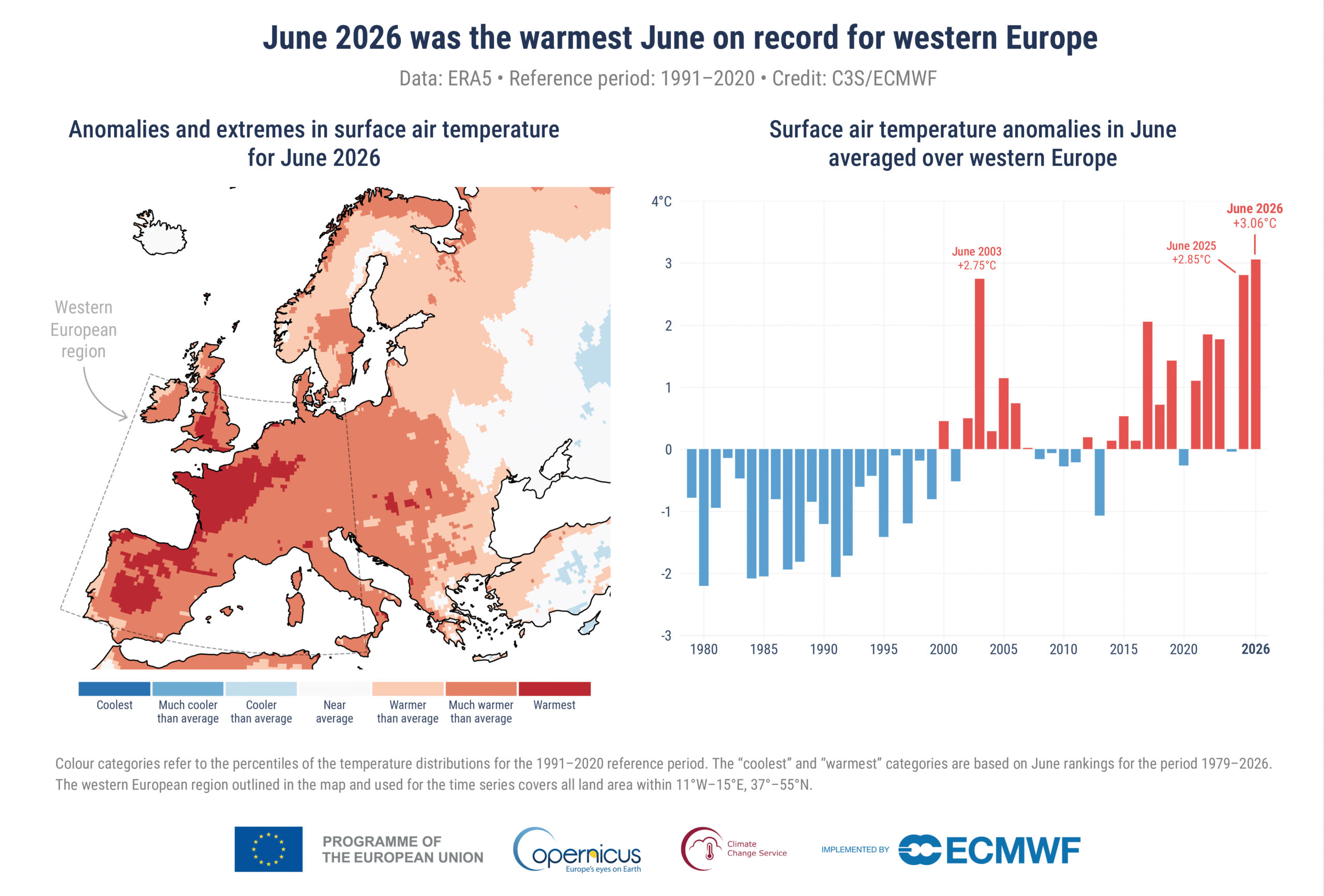
The global climate landscape this summer is defined by shifting macro-patterns and intense local thermal anomalies. According to the latest monthly climate bulletin published by the European Union’s Copernicus Climate Change Service (C3S), June 2026 was the second-warmest June on record globally, with an average surface air temperature of 16.54°C. While the global average narrowly missed the absolute top spot, Western Europe bore the brunt of a historic, persistent high-pressure system. The region recorded its absolute warmest June in history, with temperatures soaring to 20.74°C, a striking 3.05°C above the 1991–2020 reference baseline, easily eclipsing previous regional records.
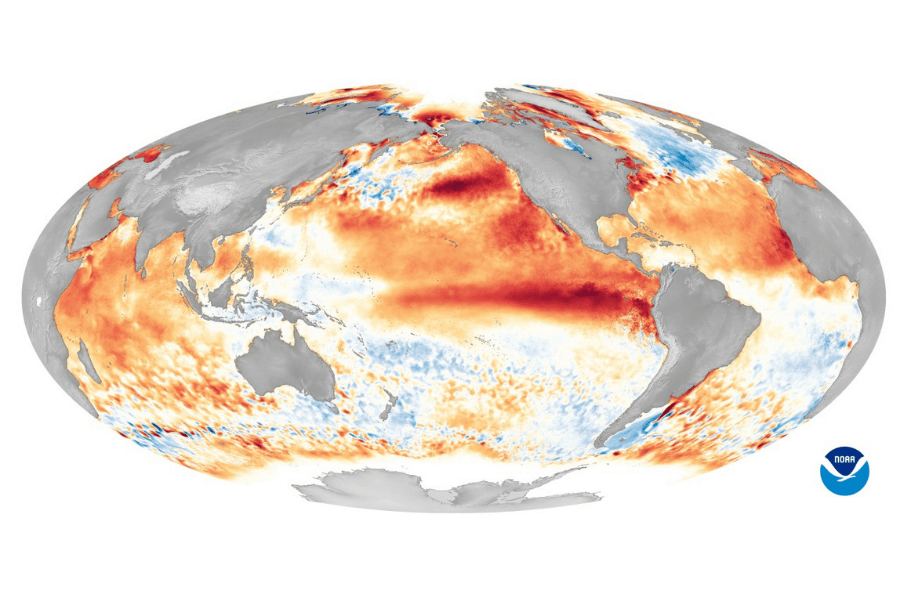
Simultaneously, the global climate engine is receiving a powerful injection of thermal energy from the tropical Pacific. In its July 9, 2026 diagnostic update, NOAA’s Climate Prediction Center officially issued an El Niño Advisory, confirming that the coupled ocean-atmosphere system is not only active but intensifying rapidly.
The equatorial Pacific is displaying profound warming trends, with the key Niño-3.4 monitoring region already reaching 1.2°C above average, signaling moderate-to-strong active conditions. Closer to South America, the Niño-1+2 zone has spiked to an extraordinary 2.7°C, fueled by downwelling Kelvin waves deepening the oceanic thermocline. Meteorologists now place the probability of this El Niño persisting through early spring 2027 at 97%. More critically, there is an 81% chance that this event will evolve into a “Very Strong” classification between October and December, potentially ranking it among the most intense climate events recorded since 1950. While European summer weather is rarely dictated directly by the Pacific, this massive accumulation of global ocean heat heavily stacks the deck for sustained, above-average thermal volatility worldwide.
A clear visualization of this climate risk comes from the latest forecast map generated by Serge Zaka at Agro Climat The model highlights a major threat to open-field tomatoes across the Mediterranean basin and France, mapping exactly where extreme temperatures hit the plants during their crucial flowering phase.
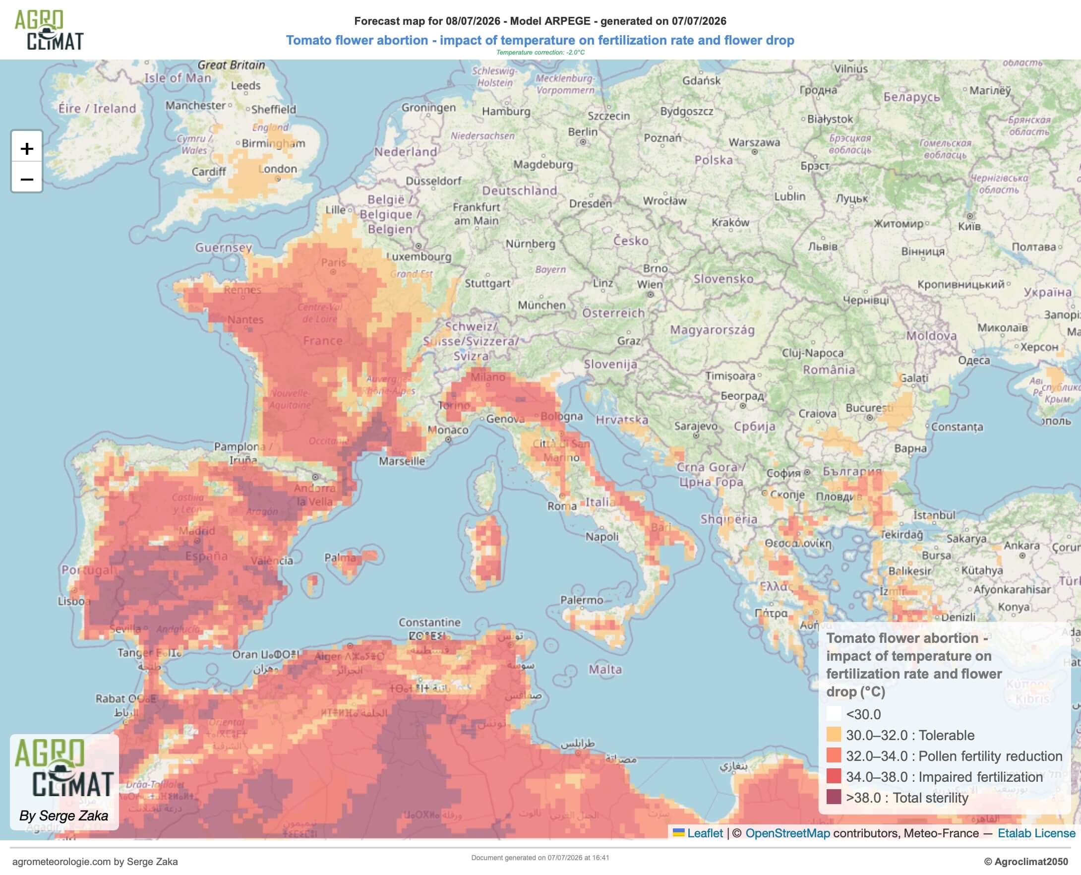
The data shows massive dark red and purple zones blanketing almost all of Spain, Portugal, southern and western France, and northern Italy’s primary growing regions. In these areas, temperatures blew right past the biological comfort zone of the tomato plant. When it gets this hot, the pollen effectively becomes sterile, causing the flowers to dry up and fall off instead of turning into fruit.
Because nothing is certain in agriculture, field experts are treating this as a serious working hypothesis rather than a definitive catastrophe. The main theory is that fields that were actively flowering during this heatwave will suffer from localized blossom drop. Rather than losing the entire crop, this will likely create “harvest gaps”, e.g. empty spaces on the vines where fruit simply failed to set. As a result, the industry should keep a close eye on mid-to-late August, when these empty weeks are expected to translate into sudden, temporary drops in delivery volumes at the processing factories.
Sources : Copernicus, Climate Prediction Center, Agro Climat