News
California drought may have permanently damaged aquifer
Around a quarter of the U.S. food supply is grown in California’s Central Valley. Most of its crops, like rice, fruit trees and nut trees, are water-intensive and require extensive groundwater pumping during droughts. Over time, heavy water extraction has contributed to changes in the aquifer systems under the San Joaquin and Sacramento valleys. Although some of these changes can be reversed, a new study, published in the Proceedings of the National Academy of Sciences, indicates that large parts of the Sacramento Valley may have undergone irreversible ground compaction during recent droughts, leading to a permanent loss of groundwater storage.
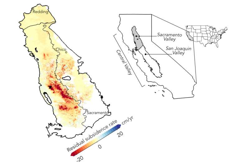
Credit: Stacy Larochelle
The looming threat of land subsidence
Pumping water out of aquifers lowers underground water pressure, which can make the land surface sink in a process called land subsidence. Moderate sinking can be reversible when water returns because of the elasticity of underground pore spaces. However, intensive pumping can permanently and inelastically compress the sediments that hold water, resulting in a permanent reduction in water storage space. Land subsidence also results in visible sinking of the surface.
The authors of the new study write, “Measurements of surface deformation over exploited aquifer systems provide a way to monitor groundwater management practices and mitigate risks including infrastructure damage, increased flood vulnerability and other socioeconomic consequences of land subsidence.“
Satellite measurements provide added insight
Well measurements can show where water levels stand but can miss stress changes in other underground layers. The study authors say that space-based geodetic techniques, such as the Global Navigation Satellite Systems (GNSS) and Interferometric Synthetic Aperture Radar (InSAR), can enhance aquifer monitoring by enabling measurements of surface deformation with far better spatial coverage, decameter resolution and millimeter-level accuracy in annual depth changes.
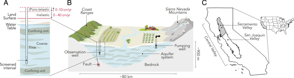
Credit: Proceedings of the National Academy of Sciences (2026). DOI: 10.1073/pnas.2526041123
The team assessed changes in the Sacramento Valley aquifer system by combining satellite radar maps of land movement with GPS station data, groundwater well records and satellite gravity measurements of regional water mass from 2016 to 2022. In doing so, they found that large parts of the Sacramento Valley abruptly shifted into mostly irreversible ground compaction in 2021, during a drought lasting from 2020 to 2022.
In the preceding 2016–2020 period, most ground movement coincided with seasonal water-level changes and was largely reversible. After 2021, some areas sank by as much as 50 centimeters (20 inches) per year, far beyond the expected reversible response of 2 centimeters (0.8 inches) per year. Estimates also showed permanent loss of groundwater storage rose about fivefold, to roughly 0.2 cubic kilometers per year in 2021–2022.
The study authors write, “All available measurements suggest that the accelerated subsidence starting in 2021 primarily results from inelastic compaction due to groundwater extraction. The rapidly subsiding areas coincide with zones of intensive pumping identified in the groundwater fluctuations and poroelastic deformation maps. Moreover, comparison of groundwater levels and InSAR displacements in the zones of accelerated subsidence shows that, on average, the ground surface does not rebound to its pre-2021 state even as groundwater levels recover with seasonal recharge at the end of 2021, indicative of irreversible deformation.“
The team notes that records from individual wells alone would not have reliably predicted where irreversible damage occurred. The study provides evidence that an aquifer can pass a damaging threshold before conventional well records give a clear warning, but satellite data may be able to detect inelastic changes sooner. Incorporating these data can help monitor groundwater stress in water-scarce regions worldwide where ground-based observations are sparse.
Potential to prevent further damage?
Further permanent damage to the Sacramento Valley aquifer is still possible. The study authors write, “While this compaction will never recover, the recent surge in precipitation in California brings hope that the aquifer system has or will soon transition back to a primarily poroelastic regime in response to decreased groundwater demand and increased recharge.”
Maps showing vulnerable areas may be used to target artificial recharge projects and reduce extraction in these zones, limiting inelastic processes. Ultimately, detecting and preventing further permanent compaction can protect roads, canals, levees, wells and flood-prone communities in the region.
Reference: Stacy Larochelle et al, Abrupt transition to irreversible damage in the overdrafted Sacramento Valley aquifer system, Proceedings of the National Academy of Sciences (2026).
Full text: DOI: 10.1073/pnas.2526041123